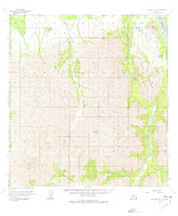
1958 Map of McGrath B-2
USGS Topo · Published 1977About this map
Farewell Airport anchors the northwestern corner of this interior Alaskan landscape, serving as a vital transport link in an area defined by massive mountain ranges and intricate river systems. The survey illustrates the dramatic elevation changes between the Terra Cotta Mountains in the southeast and the lower drainage basins to the north. Water dominates the geography, with the Post River and the S Fk Kuskokwim R carving paths through the high country. Several distinctive peaks, including Egypt Mountain and the prominent Tunis Mountain, provide navigational landmarks for the region. Numerous alpine water bodies such as Veleska Lake, Charlie Lake, and the High Lakes are scattered throughout the northern half of the quadrangle, illustrating the complex glacial and runoff patterns typical of this subarctic environment in the late 1950s.
Find a feature on this map
13 named features on this map. Tap any name to fly to it.
Don’t see what you’re looking for? This feature index may not catch every label — zoom into the map to look around manually.
Map Details
Editions of this 1958 McGrath B-2 Map
3 editions found
Other maps of this area

1949 · McGrath
USGS Topo · 1:250,000

1950 · McGrath
USGS Topo · 1:250,000

1954 · McGrath C-3
USGS Topo · 1:63,360

1958 · McGrath B-1
USGS Topo · 1:63,360

1958 · McGrath A-2
USGS Topo · 1:63,360

1958 · McGrath A-1
USGS Topo · 1:63,360

1958 · McGrath B-2
USGS Topo · 1:63,360

1958 · McGrath C-1
USGS Topo · 1:63,360

1958 · McGrath A-3
USGS Topo · 1:63,360

1958 · McGrath C-2
USGS Topo · 1:63,360