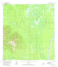
1955 Map of McGrath C-5
USGS Topo · Published 1972About this map
The Katlitna River winds through a vast expanse of wetlands and complex drainage patterns in this interior Alaska landscape. Mapped from aerial photography taken in the mid-1950s, the terrain is defined by an intricate network of marshes and low-relief basins that feed into the Big River on the eastern edge of the quadrangle. In the southwest, the topography rises sharply toward a prominent mountain mass where the headwaters of the Little Selatna River originate. This survey represents a period when large portions of the Seward Meridian remained unsurveyed on the ground, with land lines predetermined by the Bureau of Land Management rather than marked by physical monuments. The prominence of Blackwater Creek and other major waterways suggests the importance of river systems as the primary navigation corridors in this roadless region during the post-war era.
Find a feature on this map
4 named features on this map. Tap any name to fly to it.
Don’t see what you’re looking for? This feature index may not catch every label — zoom into the map to look around manually.
Map Details
Editions of this 1955 McGrath C-5 Map
2 editions found
Other maps of this area

1949 · McGrath
USGS Topo · 1:250,000

1950 · McGrath
USGS Topo · 1:250,000

1953 · McGrath D-5
USGS Topo · 1:63,360

1953 · McGrath C-4
USGS Topo · 1:63,360

1953 · McGrath D-4
USGS Topo · 1:63,360

1954 · McGrath D-6
USGS Topo · 1:63,360

1954 · McGrath B-4
USGS Topo · 1:63,360

1954 · McGrath B-6
USGS Topo · 1:63,360

1954 · McGrath C-6
USGS Topo · 1:63,360

1954 · McGrath B-5
USGS Topo · 1:63,360