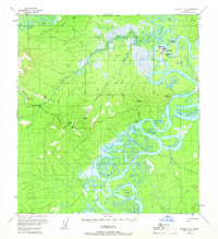
1954 Map of McGrath D-6
USGS Topo · Published 1966About this map
The confluence of the Takotna River and the Kuskokwim River serves as the focal point for this interior Alaskan landscape, which captures a period of transition for regional transport and settlement. While McGrath sits prominently on the riverbank, the map identifies Old McGrath (Abandoned) nearby, reflecting the relocation of communities along these shifting waterways. A small Cem is marked near the modern townsite, providing a point of interest for genealogists tracking early residents of the Kuskokwim region.
Find a feature on this map
31 named features on this map. Tap any name to fly to it.
Don’t see what you’re looking for? This feature index may not catch every label — zoom into the map to look around manually.
Map Details
Editions of this 1954 McGrath D-6 Map
4 editions found
Other maps of this area

1949 · McGrath
USGS Topo · 1:250,000

1950 · Medfra
USGS Topo · 1:250,000

1950 · McGrath
USGS Topo · 1:250,000

1951 · Ophir
USGS Topo · 1:250,000

1951 · Iditarod
USGS Topo · 1:250,000

1953 · McGrath D-5
USGS Topo · 1:63,360

1954 · Medfra A-6
USGS Topo · 1:63,360

1954 · McGrath D-6
USGS Topo · 1:63,360

1954 · Medfra A-5
USGS Topo · 1:63,360

1954 · Ophir A-1
USGS Topo · 1:63,360