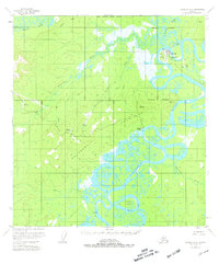
1954 Map of McGrath D-6
USGS Topo · Published 1981About this map
McGrath and its surrounding wilderness at the confluence of the Takotna River and the Kuskokwim River define the interior Alaskan landscape in this mid-century survey. The settlement of Old McGrath is marked as abandoned on the northern riverbank, signaling the community's shift to its modern location. This shift, along with the presence of a Heliport, Radio Facility, and Gaging Sta, underscores the importance of aviation and communication in this isolated region. To the south, the intricate oxbows and sloughs of the Kuskokwim River wrap around Harrell Island, while the Roundabout Hills and Mountains rise above the drainage basins. Industrial activity is noted at the Candle Placer mine along Candle Creek, supported by the remote Candle Creek Landing Strip, illustrating the persistent search for minerals in the Yukon-Koyukuk territory.
Find a feature on this map
26 named features on this map. Tap any name to fly to it.
Don’t see what you’re looking for? This feature index may not catch every label — zoom into the map to look around manually.
Map Details
Editions of this 1954 McGrath D-6 Map
4 editions found
Other maps of this area

1949 · McGrath
USGS Topo · 1:250,000

1950 · Medfra
USGS Topo · 1:250,000

1950 · McGrath
USGS Topo · 1:250,000

1951 · Ophir
USGS Topo · 1:250,000

1951 · Iditarod
USGS Topo · 1:250,000

1953 · McGrath D-5
USGS Topo · 1:63,360

1954 · Medfra A-6
USGS Topo · 1:63,360

1954 · McGrath D-6
USGS Topo · 1:63,360

1954 · Medfra A-5
USGS Topo · 1:63,360

1954 · Ophir A-1
USGS Topo · 1:63,360