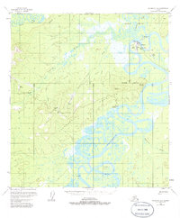
1954 Map of McGrath D-6
USGS Topo · Published 1986About this map
McGrath serves as the focal point of this interior Alaskan landscape, situated at the confluence of the Takotna River and the braided Kuskokwim River. The map captures a period of transition and remote infrastructure, noted by the presence of Old McGrath (Aband) and a variety of aviation landmarks including a heliport and multiple landing strips. The interior geography is defined by complex water systems like the Tatalina River and Katlitna River, alongside the elevated Roundabout Hills. Resource extraction and river transport are evident at the Candle (Placer) mine and Sterling Landing. The layout of local cabins and radio facilities reflects the mid-century reliance on river corridors and early bush aviation for connectivity in the Alaskan wilderness.
Find a feature on this map
29 named features on this map. Tap any name to fly to it.
Don’t see what you’re looking for? This feature index may not catch every label — zoom into the map to look around manually.
Map Details
Editions of this 1954 McGrath D-6 Map
4 editions found
Other maps of this area

1949 · McGrath
USGS Topo · 1:250,000

1950 · Medfra
USGS Topo · 1:250,000

1950 · McGrath
USGS Topo · 1:250,000

1951 · Ophir
USGS Topo · 1:250,000

1951 · Iditarod
USGS Topo · 1:250,000

1953 · McGrath D-5
USGS Topo · 1:63,360

1954 · Medfra A-6
USGS Topo · 1:63,360

1954 · McGrath D-6
USGS Topo · 1:63,360

1954 · Medfra A-5
USGS Topo · 1:63,360

1954 · Ophir A-1
USGS Topo · 1:63,360