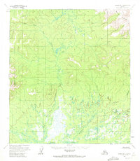
1953 Map of Medfra B-5
USGS Topo · Published 1972About this map
The Sunshine Mountains dominate the northeastern corner of this sub-arctic landscape, providing a high-elevation backdrop to a complex network of low-lying wetlands. The drainage system is defined by the winding course of the West Fork Nixon Fork, which meanders through the central and western sections of the map, eventually joining the main Nixon Fork in the south. This 1953 field-annotated survey reveals a terrain largely shaped by water, where the mountain slopes descend into vast areas of swamps and braided streams. To the east, the headwaters of Washington Creek snake through the valley floor, illustrating the intricate hydrology typical of the Yukon-Koyukuk region before significant modern development. The absence of named settlements or roads underscores the wilderness character of the interior during the early 1950s.
Find a feature on this map
10 named features on this map. Tap any name to fly to it.
Don’t see what you’re looking for? This feature index may not catch every label — zoom into the map to look around manually.
Map Details
Editions of this 1953 Medfra B-5 Map
2 editions found
Other maps of this area

1950 · Medfra
USGS Topo · 1:250,000

1953 · Medfra B-4
USGS Topo · 1:63,360

1953 · Medfra B-5
USGS Topo · 1:63,360

1953 · Medfra C-4
USGS Topo · 1:63,360

1954 · Medfra A-6
USGS Topo · 1:63,360

1954 · Medfra A-5
USGS Topo · 1:63,360

1954 · Medfra C-6
USGS Topo · 1:63,360

1954 · Medfra C-5
USGS Topo · 1:63,360

1954 · Medfra B-6
USGS Topo · 1:63,360
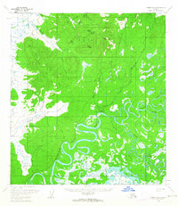
1959 · Medfra A-4
USGS Topo · 1:63,360