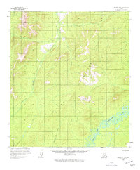
1958 Map of Medfra D-1
USGS Topo · Published 1977About this map
The North Fork Kuskokwim River anchors the southeastern corner of this Alaskan interior landscape, where the vast drainage systems of the Sischu Mountains converge. Recorded during the mid-1950s, the map reveals a wilderness largely defined by its watercourses and elevation, with the Sethkokna River winding through the central valley. A single Cabin located near the headwaters of Sischu Creek and a primitive Winter Trail running north-south through the western foothills suggest the seasonal movements of trappers or indigenous travelers of the era.
Find a feature on this map
12 named features on this map. Tap any name to fly to it.
Don’t see what you’re looking for? This feature index may not catch every label — zoom into the map to look around manually.
Map Details
Editions of this 1958 Medfra D-1 Map
3 editions found

Other maps of this area

1948 · Kantishna River
USGS Topo · 1:250,000

1950 · Medfra
USGS Topo · 1:250,000

1951 · Kantishna River
USGS Topo · 1:250,000

1951 · Ruby
USGS Topo · 1:250,000

1952 · Mount McKinley
USGS Topo · 1:250,000

1952 · Ruby A-2
USGS Topo · 1:63,360

1952 · Ruby A-1
USGS Topo · 1:63,360

1952 · Kantishna River
USGS Topo · 1:250,000

1952 · Kantishna River A-6
USGS Topo · 1:63,360

1952 · Ruby
USGS Topo · 1:250,000