
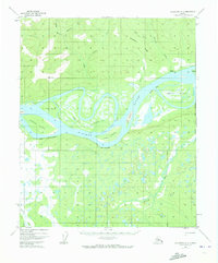
1952 Map of Melozitna A-1
USGS Topo · Published 1958About this map
The Yukon River dominates this mid-century interior landscape, winding through a complex system of braided channels and expansive islands. This 1952 survey, based on aerial photography, documents a remote stretch of the river corridor where small settlements like Kallands and Birches represent the sparse human footprint. The river's dynamic nature is evident in the named side channels and islands, including Cronin Island, Flora Island, and Weir Island, which are separated by waterways such as Mason Slough and Clayhill Slough. To the south, the dramatic elevation change of The Palisades overlooks the main channel, while the interior is crisscrossed by tributaries like Blind River and the Klatatuta River. The presence of several Cabin labels near points like Painter Pt and Clay Pt indicates the seasonal or subsistence use of these riverine resources in the early postwar era.
Find a feature on this map
27 named features on this map. Tap any name to fly to it.
Don’t see what you’re looking for? This feature index may not catch every label — zoom into the map to look around manually.
Map Details
Editions of this 1952 Melozitna A-1 Map
2 editions found
Other maps of this area

1948 · Kantishna River
USGS Topo · 1:250,000

1951 · Kantishna River
USGS Topo · 1:250,000

1951 · Ruby
USGS Topo · 1:250,000

1951 · Melozitna
USGS Topo · 1:250,000

1951 · Tanana
USGS Topo · 1:250,000

1952 · Melozitna A-2
USGS Topo · 1:63,360

1952 · Ruby D-1
USGS Topo · 1:63,360

1952 · Kantishna River
USGS Topo · 1:250,000

1952 · Tanana A-6
USGS Topo · 1:63,360

1952 · Kantishna River D-6
USGS Topo · 1:63,360