
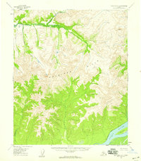
1952 Map of Melozitna A-2
USGS Topo · Published 1957About this map
Gold Mountain dominates the northern interior of this Alaskan interior survey, which centers on a major bend of the Yukon River during the early 1950s. The landscape is defined by the shifting hydrology of the river, marked by large landmasses like Young Island, Lady Island, and Chokoyik Island separated by channels such as Pike Slough. Traces of human activity are sparse but significant, indicating a seasonal and transport-oriented economy. A Native Fishing Camp sits on the riverbank near the confluence with Birches Creek, while a Landing Strip (CAA) nearby provided a critical link for small aircraft. Several Cabins are noted along the banks between Ninemile Pt and Lady Pt, representing the remote outposts of the territory before Alaskas statehood.
Find a feature on this map
19 named features on this map. Tap any name to fly to it.
Don’t see what you’re looking for? This feature index may not catch every label — zoom into the map to look around manually.
Map Details
Editions of this 1952 Melozitna A-2 Map
This is the sole edition of this map. No revisions or reprints were ever made.
Other maps of this area

1951 · Ruby
USGS Topo · 1:250,000

1951 · Melozitna
USGS Topo · 1:250,000

1952 · Ruby D-1
USGS Topo · 1:63,360

1952 · Ruby D-3
USGS Topo · 1:63,360

1952 · Ruby D-2
USGS Topo · 1:63,360

1952 · Ruby
USGS Topo · 1:250,000

1952 · Melozitna A-1
USGS Topo · 1:63,360

1953 · Melozitna A-2
USGS Topo · 1:63,360

1954 · Melozitna B-3
USGS Topo · 1:63,360
1954 · Melozitna A-3
USGS Topo · 1:63,360