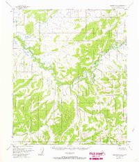
1952 Map of Melozitna A-6
USGS Topo · Published 1967About this map
The meandering Dulbi River dominates this interior landscape, carving a serpentine path through the low-lying terrain of the Yukon-Koyukuk region. Based on aerial photography from the early 1950s, the survey captures an expansive wilderness characterized by complex wetland patterns and dense swamp systems typical of the Alaskan interior. The lack of named settlements, roads, or trails reflects the isolation of the area during this era, where the primary geographical features are defined by the water's movement and the subtle elevation changes of the surrounding flats. The Dulbi River serves as the singular named landmark, emphasizing its role as the central drainage artery for this portion of the Melozitna quadrangle.
Find a feature on this map
1 named feature on this map. Tap any name to fly to it.
Don’t see what you’re looking for? This feature index may not catch every label — zoom into the map to look around manually.
Map Details
Editions of this 1952 Melozitna A-6 Map
2 editions found
Other maps of this area

1945 · Nulato
USGS Topo · 1:250,000

1951 · Nulato
USGS Topo · 1:250,000

1951 · Ruby
USGS Topo · 1:250,000

1951 · Kateel River
USGS Topo · 1:250,000

1951 · Melozitna
USGS Topo · 1:250,000

1952 · Nulato D-1
USGS Topo · 1:63,360

1952 · Ruby D-6
USGS Topo · 1:63,360

1952 · Kateel River A-1
USGS Topo · 1:63,360

1952 · Ruby D-5
USGS Topo · 1:63,360

1952 · Kateel River B-1
USGS Topo · 1:63,360