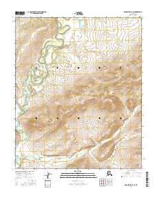
2016 Map of Melozitna B-4 SE
USGS Topo · Published 2016About this map
The Yukon-Koyukuk region of interior Alaska is depicted here in a high-resolution 2016 survey, focusing on the intricate hydrology and varied topography of the Melozitna B-4 SE quadrangle. The landscape is defined by the complex, meandering river system flowing through T1s R20e, where numerous oxbow lakes and abandoned channels indicate a highly dynamic fluvial environment. This drainage network contrasts sharply with the rising elevations found to the southeast in T2s R21e, where the terrain transitions into a series of ridges and valleys. While the area remains largely undeveloped, the map provides precise section-line data for several townships, including T2s R20e and T3s R21e, offering an essential foundation for understanding the public land survey system in this remote portion of the Alaskan interior.
Find a feature on this map
6 named features on this map. Tap any name to fly to it.
Don’t see what you’re looking for? This feature index may not catch every label — zoom into the map to look around manually.
Map Details
Editions of this 2016 Melozitna B-4 SE Map
This is the sole edition of this map. No revisions or reprints were ever made.
Other maps of this area

1951 · Melozitna
USGS Topo · 1:250,000

1953 · Melozitna A-4
USGS Topo · 1:63,360

1954 · Melozitna B-3
USGS Topo · 1:63,360
1954 · Melozitna A-3
USGS Topo · 1:63,360
1954 · Melozitna B-4
USGS Topo · 1:63,360

1956 · Melozitna
USGS Topo · 1:250,000
2016 · Melozitna B-3 SW
USGS Topo · 1:25,000
2016 · Melozitna A-4 NW
USGS Topo · 1:25,000
2016 · Melozitna B-3 NW
USGS Topo · 1:25,000
2016 · Melozitna B-4 NW
USGS Topo · 1:25,000