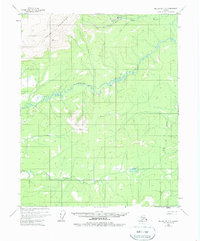
1955 Map of Melozitna D-2
USGS Topo · Published 1963About this map
Utopia stands as a primary point of human activity in this mid-century survey of the Alaskan interior, situated near the northern edge of the map. The settlement is supported by a local Landing Strip, highlighting the critical role of aviation for logistics and access in this region. The landscape is dominated by the Indian Mountains, which rise to significant elevations at peaks like VABM 3932 Pochontas.
Find a feature on this map
12 named features on this map. Tap any name to fly to it.
Don’t see what you’re looking for? This feature index may not catch every label — zoom into the map to look around manually.
Map Details
Editions of this 1955 Melozitna D-2 Map
3 editions found
Other maps of this area

1951 · Hughes
USGS Topo · 1:250,000

1951 · Melozitna
USGS Topo · 1:250,000

1952 · Melozitna D-1
USGS Topo · 1:63,360

1952 · Melozitna D-3
USGS Topo · 1:63,360

1954 · Melozitna C-3
USGS Topo · 1:63,360

1954 · Melozitna D-3
USGS Topo · 1:63,360

1955 · Melozitna D-2
USGS Topo · 1:63,360

1955 · Hughes A-2
USGS Topo · 1:63,360

1955 · Hughes A-1
USGS Topo · 1:63,360

1955 · Hughes A-3
USGS Topo · 1:63,360