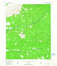
1955 Map of Melozitna D-2
USGS Topo · Published 1963About this map
The Indian Mountains dominate the northwestern corner of this interior Alaska landscape, providing a backdrop for the isolated settlement of Utopia. Located along the banks of Utopia Creek, this remote outpost is supported by a designated Landing Strip, illustrating the importance of bush aviation in the mid-1950s. The drainage system is defined by the winding course of the Indian River and its southern counterpart, the Little Indian River, which carve through a network of creeks including Flat Creek and the curiously named Macaroni Creek. Surveyors established high-altitude control points at VABM 3932 Pocahontas and VABM 2139 Cone to map this complex terrain. The map captures a moment when transport was tied strictly to the water and air, with no major roads penetrating the valley floor.
Find a feature on this map
12 named features on this map. Tap any name to fly to it.
Don’t see what you’re looking for? This feature index may not catch every label — zoom into the map to look around manually.
Map Details
Editions of this 1955 Melozitna D-2 Map
3 editions found
Other maps of this area

1951 · Hughes
USGS Topo · 1:250,000

1951 · Melozitna
USGS Topo · 1:250,000

1952 · Melozitna D-1
USGS Topo · 1:63,360

1952 · Melozitna D-3
USGS Topo · 1:63,360

1954 · Melozitna C-3
USGS Topo · 1:63,360

1954 · Melozitna D-3
USGS Topo · 1:63,360

1955 · Melozitna D-2
USGS Topo · 1:63,360

1955 · Hughes A-2
USGS Topo · 1:63,360

1955 · Hughes A-1
USGS Topo · 1:63,360

1955 · Hughes A-3
USGS Topo · 1:63,360