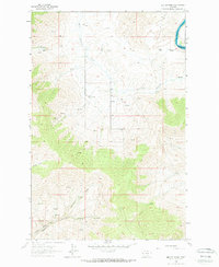
1964 Map of Melton Ranch
USGS Topo · Published 1966About this map
The Little Bitterroot River and its varied tributaries define the landscape of this 1964 survey, capturing a specific era of high-country agriculture and ranching. Family-run operations like the Melton Ranch, Jennings Ranch, and Anderson Ranch are recorded along the valley floor, connected by unimproved dirt roads that follow the natural contours of the land. The topography transitions from the alluvial plains of the river to steeper terrain marked by distinctive landforms such as Racehorse Gulch and Ferry Basin.
Find a feature on this map
17 named features on this map. Tap any name to fly to it.
Don’t see what you’re looking for? This feature index may not catch every label — zoom into the map to look around manually.
Map Details
Editions of this 1964 Melton Ranch Map
2 editions found
Other maps of this area

1920 · Flathead Lake
USGS Topo · 1:125,000

1956 · Wallace
USGS Topo · 1:250,000

1959 · Perma
USGS Topo · 1:62,500

1960 · Wallace
USGS Topo · 1:250,000

1964 · Dixon
USGS Topo · 1:24,000

1964 · Mc Donald
USGS Topo · 1:24,000

1964 · Melton Ranch
USGS Topo · 1:24,000

1964 · Markle Pass
USGS Topo · 1:24,000

1965 · Sloan
USGS Topo · 1:24,000

1965 · Oliver Point
USGS Topo · 1:24,000