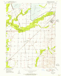
1949 Map of Mendon
USGS Topo · Published 1956About this map
The sprawling bottomlands of Swan Lake National Wildlife Refuge dominate this late 1940s landscape, where Swan Lake and Silver Lake fill a vast basin between Elk Creek and Yellow Creek. This area of Chariton County reveals a complex intersection of early conservation efforts and established rural infrastructure. The rail-and-river economy is clearly visible through the paths of the Atchison Topeka and Santa Fe and Wabash railroads, which served the small communities of Mendon, Whitham, and Triplett. Local genealogy and social history are preserved in the locations of the Stephenson Sch, Stephenson Cem, and Jackson Cem. Farther south, the community of Dean Lake and the Snyder P O sit near the meandering banks of Salt Creek, illustrating the dispersed settlement patterns typical of Missouri's floodplains before modern land-use changes.
Find a feature on this map
27 named features on this map. Tap any name to fly to it.
Don’t see what you’re looking for? This feature index may not catch every label — zoom into the map to look around manually.
Map Details
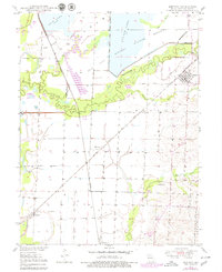
Editions of this 1949 Mendon Map
3 editions found
Other maps of this area

1890 · Marshall
USGS Topo · 1:125,000

1892 · Marshall
USGS Topo · 1:125,000

1901 · Marshall
USGS Topo · 1:125,000

1924 · Hale
USGS Topo · 1:62,500

1949 · Mendon
USGS Topo · 1:24,000

1949 · Indian Grove
USGS Topo · 1:24,000

1949 · Sumner
USGS Topo · 1:24,000

1949 · Rothville
USGS Topo · 1:24,000

1950 · Sumner
USGS Topo · 1:24,000

1950 · Rothville
USGS Topo · 1:24,000