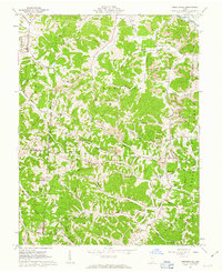
1961 Map of Mercerville
USGS Topo · Published 1963About this map
Wayne National Forest dominates the ridgelines of this part of Gallia Co and Lawrence Co in the early 1960s. The landscape is defined by its extensive drainage network, including Indian Guyan Creek, Perigen Creek, and Raccoon Creek, which carve through the townships of Harrison, Guyan, and Mason. Numerous Strip Mines are visible across the hills, indicating the active extractive industry of the era, while a Lookout Tower sits atop a high point near Fairview.
Find a feature on this map
72 named features on this map. Tap any name to fly to it.
Don’t see what you’re looking for? This feature index may not catch every label — zoom into the map to look around manually.
Map Details
Editions of this 1961 Mercerville Map
4 editions found
Other maps of this area

1906 · Bidwell
USGS Topo · 1:62,500

1906 · Athalia
USGS Topo · 1:62,500

1906 · Glenwood
USGS Topo · 1:62,500

1908 · Bidwell
USGS Topo · 1:62,500

1908 · Athalia
USGS Topo · 1:62,500

1908 · Glenwood
USGS Topo · 1:62,500

1908 · Point Pleasant
USGS Topo · 1:62,500

1926 · Point Pleasant
USGS Topo · 1:62,500

1929 · Point Pleasant
USGS Topo · 1:62,500

1957 · Huntington
USGS Topo · 1:250,000