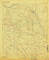
1894 Map of Meridian
USGS Topo · Published 1919About this map
The Bosque River valley and its surrounding hill country are defined by a late nineteenth-century landscape of rising rail hubs and livestock-raising settlements. Surveyed in 1886, the map captures Meridian and Clifton as they grew alongside the Gulf Colorado and Santa Fe Railroad, while Iredell served the northwest on the Texas Central Railroad. Beyond the tracks, the terrain is marked by distinctive limestone features and small communities like Norse and Jonesborough, indicating the early agrarian footprint of Central Texas.
Find a feature on this map
57 named features on this map. Tap any name to fly to it.
Don’t see what you’re looking for? This feature index may not catch every label — zoom into the map to look around manually.
Map Details
Editions of this 1894 Meridian Map
3 editions found
Other maps of this area

1887 · Lampasas
USGS Topo · 1:125,000

1888 · Hamilton
USGS Topo · 1:125,000

1888 · Meridian
USGS Topo · 1:125,000

1889 · Granbury
USGS Topo · 1:125,000

1890 · Stephenville
USGS Topo · 1:125,000

1891 · Cleburne
USGS Topo · 1:125,000

1892 · Temple
USGS Topo · 1:125,000

1892 · Waco
USGS Topo · 1:125,000

1894 · Hamilton
USGS Topo · 1:125,000

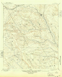
1894 · Meridian
USGS Topo · 1:125,000