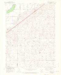
1951 Map of Merino SW
USGS Topo · Published 1972About this map
The South Platte River valley defines the northwestern corner of this landscape, where the Lower Platte Ditch skirts the fertile river bottom. Irrigation infrastructure, including the Beaver Creek drainage and numerous windmills scattered across the high plains, reveals the agricultural adaptation required in the semi-arid region during the mid-20th century. The Union Pacific railroad cuts a diagonal line across the terrain, reflecting the vital transportation corridor connecting eastern Colorado to larger markets. Inland from the river, the Highland School stands as a solitary center for the surrounding rural community, situated along the county line between Morgan and Washington counties. The terrain is marked by the depressions of Emerson Lake and the undulating contours of the plains, where isolated windmills served as essential landmarks for local ranching and farming operations.
Find a feature on this map
9 named features on this map. Tap any name to fly to it.
Don’t see what you’re looking for? This feature index may not catch every label — zoom into the map to look around manually.
Map Details
Editions of this 1951 Merino SW Map
5 editions found
Other maps of this area

1951 · Messex
USGS Topo · 1:24,000

1951 · Antelope Springs
USGS Topo · 1:24,000

1951 · Merino SW
USGS Topo · 1:24,000

1951 · Brush East
USGS Topo · 1:24,000

1951 · Merino SE
USGS Topo · 1:24,000

1951 · Merino
USGS Topo · 1:24,000

1954 · Sterling
USGS Topo · 1:250,000

1958 · Sterling
USGS Topo · 1:250,000

1965 · Miller Ranch
USGS Topo · 1:24,000

1971 · Brush East
USGS Topo · 1:24,000