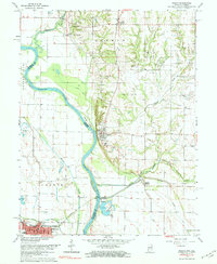
1966 Map of Merom
USGS Topo · Published 1983About this map
Merom Bluff stands as a prominent landmark overlooking the Wabash River in this mid-century survey of the Indiana-Illinois border. The landscape is defined by the river's winding course, which creates significant landforms like Merom Island and Eagle Island. On the Indiana side, the town of Merom and the smaller settlement of Riverton serve as local hubs, while Palestine occupies the Illinois bank to the southwest. The presence of several family and community burial grounds, such as Massey Cem, Old French Cem, and Mann Cem, provides valuable points of interest for genealogists tracing early families in Sullivan County and Crawford County. Transportation infrastructure is prominently featured, including the Illinois Central railroad line passing through Merom (Station). The map also records the region's natural drainage through Turtle Creek and Turman Creek, alongside signs of local industry like various Oil Wells and a Mine Dump.
Find a feature on this map
39 named features on this map. Tap any name to fly to it.
Don’t see what you’re looking for? This feature index may not catch every label — zoom into the map to look around manually.
Map Details
Editions of this 1966 Merom Map
4 editions found
Other maps of this area

1917 · Birds
USGS Topo · 1:62,500

1942 · Fairbanks
USGS Topo · 1:24,000

1942 · Shelburn
USGS Topo · 1:24,000

1942 · Birds
USGS Topo · 1:62,500

1943 · Merom
USGS Topo · 1:24,000

1943 · Carlisle
USGS Topo · 1:24,000

1943 · Sullivan
USGS Topo · 1:24,000

1952 · Fairbanks
USGS Topo · 1:24,000

1952 · Shelburn
USGS Topo · 1:24,000

1953 · Indianapolis
USGS Topo · 1:250,000