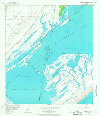
1952 Map of Mesquite Bay
USGS Topo · Published 1967About this map
Aransas National Wildlife Refuge dominates the western shore of this 1952 coastal survey, where the Blackjack Peninsula reaches into the complex waters of San Antonio Bay and Mesquite Bay. This landscape is defined by the shifting boundaries of land and water, featuring the Second Chain of Islands and the Third Chain of Islands which separate the larger bays from smaller inlets like Ayres Bay. The map documents early petroleum activity with scattered Gas Wells and an Oil Well near False Live Oak Point, while the Intracoastal Waterway cuts through the bays with a noted project depth of 12 feet. On Matagorda Island, the interior is a network of salt lakes including Big Brundrett Lake and Little Brundrett Lake, reflecting the wild, undeveloped character of the Texas Gulf coast before modern infrastructure.
Find a feature on this map
44 named features on this map. Tap any name to fly to it.
Don’t see what you’re looking for? This feature index may not catch every label — zoom into the map to look around manually.
Map Details
Editions of this 1952 Mesquite Bay Map
4 editions found
Other maps of this area

1952 · Mosquito Point
USGS Topo · 1:24,000

1952 · St. Charles Bay SW
USGS Topo · 1:24,000

1952 · St. Charles Bay
USGS Topo · 1:24,000

1952 · Mesquite Bay
USGS Topo · 1:24,000

1952 · Tivoli SE
USGS Topo · 1:24,000

1952 · Panther Point
USGS Topo · 1:24,000

1952 · Tivoli SW
USGS Topo · 1:24,000

1952 · St. Charles Bay SE
USGS Topo · 1:24,000

1953 · Beeville
USGS Topo · 1:250,000

1956 · Beeville
USGS Topo · 1:250,000