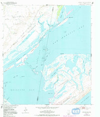
1952 Map of Mesquite Bay
USGS Topo · Published 1991About this map
The Aransas National Wildlife Refuge dominates the coastal landscape of this mid-century survey, spanning the transition from the Black Jack Peninsula into the expansive waters of San Antonio Bay. The environment is defined by a complex network of barrier islands and tidal flats, including Matagorda Island and the Second Chain of Islands. Evidence of early industrial and ranching activity is scattered throughout the marshy terrain, seen in the presence of Carlos Windmills, the Jack Windmill, and several isolated gas and oil wells. Navigation is anchored by the Intracoastal Waterway, which cuts a straight path through the natural curves of Sundown Bay and Ayres Bay. Researchers can trace the intricate shoreline of Big Brundrett Lake and the various man-made channels like the Ayres Dugout that facilitated movement through these shallow Texas coastal waters.
Find a feature on this map
43 named features on this map. Tap any name to fly to it.
Don’t see what you’re looking for? This feature index may not catch every label — zoom into the map to look around manually.
Map Details
Editions of this 1952 Mesquite Bay Map
4 editions found
Other maps of this area

1952 · Mosquito Point
USGS Topo · 1:24,000

1952 · St. Charles Bay SW
USGS Topo · 1:24,000

1952 · St. Charles Bay
USGS Topo · 1:24,000

1952 · Mesquite Bay
USGS Topo · 1:24,000

1952 · Tivoli SE
USGS Topo · 1:24,000

1952 · Panther Point
USGS Topo · 1:24,000

1952 · Tivoli SW
USGS Topo · 1:24,000

1952 · St. Charles Bay SE
USGS Topo · 1:24,000

1953 · Beeville
USGS Topo · 1:250,000

1956 · Beeville
USGS Topo · 1:250,000