
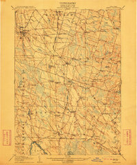
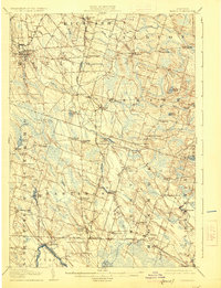
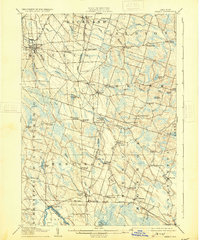
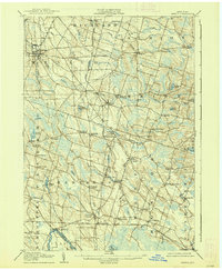
1905 Map of Mexico
USGS Topo · Published 1905About this map
Mexico serves as a primary hub in this early twentieth-century snapshot of Oswego County, where a network of family-named corners and rural settlements define the inland landscape. The area is heavily influenced by the drainage patterns of the Salmon River and Little Salmon River, which supported local industry like the Gravel Millpond and Carleys Mills. This period shows a complex rail infrastructure, with the Rome Watertown and Ogdensburg RR and the New York Central and Hudson River RR intersecting to move goods and passengers through stops like Mallory Sta and Hastings Sta. Further south, the map captures the northern edge of Oneida River and the marshes of Big Bay Oneida L. Local history is preserved in the numerous named crossroads such as Gardiners Corners, Prattham, and Roosevelt Cors, which suggest a settled agricultural society before modern highway expansion.
Find a feature on this map
77 named features on this map. Tap any name to fly to it.
Don’t see what you’re looking for? This feature index may not catch every label — zoom into the map to look around manually.
Map Details
Editions of this 1905 Mexico Map
6 editions found

Other maps of this area

1895 · Chittenango
USGS Topo · 1:62,500

1895 · Pulaski
USGS Topo · 1:62,500

1895 · Syracuse
USGS Topo · 1:62,500

1898 · Syracuse
USGS Topo · 1:62,500

1898 · Chittenango
USGS Topo · 1:62,500

1900 · Baldwinsville
USGS Topo · 1:62,500

1900 · Fulton
USGS Topo · 1:62,500

1902 · Chittenango
USGS Topo · 1:62,500

1903 · Orwell
USGS Topo · 1:62,500

1905 · Orwell
USGS Topo · 1:62,500