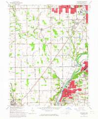
1965 Map of Miamisburg
USGS Topo · Published 1967About this map
The Great Miami River valley south of Dayton is defined by a dense mix of industrial activity and historical landmarks during the mid-1960s. Miamisburg and West Carrollton anchor the eastern bank, connected by the Baltimore and Ohio and Penn Central railroads. A significant footprint is occupied by the Mound Laboratory and the adjacent Miamisburg Mound State Memorial, reflecting the region's intersection of ancient history and Cold War era scientific advancement. To the north, the Veterans Administration Center and the Dayton Correction Farm sit near growing residential developments like Drexel and Ridgewood Heights. West of the river, the landscape of Jefferson and German townships remains largely agricultural, punctuated by local landmarks like Ellerton and the West Memory Gardens Cem. Small crossroads settlements like Liberty and Frytown appear alongside rural institutions such as the Salem Churches and Township Schools.
Find a feature on this map
98 named features on this map. Tap any name to fly to it.
Don’t see what you’re looking for? This feature index may not catch every label — zoom into the map to look around manually.
Map Details
Editions of this 1965 Miamisburg Map
4 editions found
Other maps of this area

1904 · Dayton
USGS Topo · 1:62,500

1905 · Brookville
USGS Topo · 1:62,500

1906 · Dayton
USGS Topo · 1:62,500

1908 · Miamisburg
USGS Topo · 1:62,500

1913 · Waynesville
USGS Topo · 1:62,500

1915 · Waynesville
USGS Topo · 1:62,500

1951 · Franklin
USGS Topo · 1:24,000

1953 · Cincinnati
USGS Topo · 1:250,000

1955 · Miamisburg
USGS Topo · 1:24,000

1955 · Dayton South
USGS Topo · 1:24,000