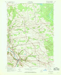
1943 Map of Middleville
USGS Topo · Published 1969About this map
West Canada Creek winds through the southwestern corner of this wartime survey, anchoring the settlement of Middleville. This upland terrain of Herkimer County is defined by small agricultural hamlets and crossroads communities like Norway and Fairfield, which served as local hubs before the shift toward larger regional centers. The map documents a landscape of high ridges and hollows, including Dairy Hill and Wolf Hollow, where the placement of rural institutions reflects the decentralized life of the early 1940s. Local researchers will find specific genealogical landmarks such as Hardscrabble Cem and Sweet Cem, alongside the scattered one-room schoolhouses like Black Creek Sch and School No 7 that once served these hillsides. The northern edge touches the boundary of Adirondack State Park, where the environment transitions toward the dense woods and marshes of Huckleberry Swamp and the waters of Black Creek Reservoir.
Find a feature on this map
28 named features on this map. Tap any name to fly to it.
Don’t see what you’re looking for? This feature index may not catch every label — zoom into the map to look around manually.
Map Details
Editions of this 1943 Middleville Map
Other maps of this area

1897 · Remsen
USGS Topo · 1:62,500

1898 · Utica
USGS Topo · 1:62,500

1900 · Little Falls
USGS Topo · 1:62,500

1900 · Utica
USGS Topo · 1:62,500

1900 · Remsen
USGS Topo · 1:62,500

1900 · Wilmurt
USGS Topo · 1:62,500

1902 · Wilmurt
USGS Topo · 1:62,500

1903 · Little Falls
USGS Topo · 1:62,500

1939 · Little Falls
USGS Topo · 1:62,500

1943 · Newport
USGS Topo · 1:24,000