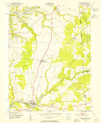
1953 Map of Millington
USGS Topo · Published 1955About this map
The Chester River and Sassafras River define the northern and southern bounds of this mid-century landscape, where the Pennsylvania railroad lines intersect at Massey. This agricultural corridor along the Maryland Delaware border is dotted with small crossroads and river landings that once served as vital points of trade and transport. In the southern portion of the map, Millington sits at a historic crossing of the river, surrounded by sites of local heritage like the Mission Ch and St Clements Ch. The topography shows a transition from the tidal marshes of Hen Island and Foxhole Landing to the managed landscapes of the Millington Wildlife Demonstration Area. The map captures the region before extensive modernization, preserving the locations of rural schools, family-named junctions such as Peacock Corners, and the intricate network of mill ponds and branches that fed the local economy.
Find a feature on this map
48 named features on this map. Tap any name to fly to it.
Don’t see what you’re looking for? This feature index may not catch every label — zoom into the map to look around manually.
Map Details
Editions of this 1953 Millington Map
3 editions found
Other maps of this area

1899 · Dover
USGS Topo · 1:125,000

1900 · Cecilton
USGS Topo · 1:62,500

1905 · Barclay
USGS Topo · 1:62,500

1906 · Dover
USGS Topo · 1:125,000

1920 · Dover
USGS Topo · 1:125,000

1926 · Wyoming
USGS Topo · 1:48,000

1930 · Wyoming
USGS Topo · 1:62,500

1931 · Wyoming
USGS Topo · 1:62,500

1931 · Smyrna
USGS Topo · 1:62,500
1944 · Earleville
USGS Topo · 1:31,680