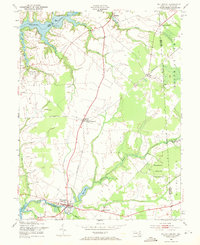
1953 Map of Millington
USGS Topo · Published 1971About this map
The Chester River and Sassafras River define the northern and southern reaches of this landscape where the Maryland-Delaware border meets the intersection of Kent, Queen Annes, and Cecil counties. During the early 1950s, the agricultural character of the region was connected by the Pennsylvania railroad, which served small rural junctions and settlements. The town of Millington sits at a strategic river crossing, flanked by the Andover and Four Corners communities.
Find a feature on this map
41 named features on this map. Tap any name to fly to it.
Don’t see what you’re looking for? This feature index may not catch every label — zoom into the map to look around manually.
Map Details
Editions of this 1953 Millington Map
3 editions found
Other maps of this area

1899 · Dover
USGS Topo · 1:125,000

1900 · Cecilton
USGS Topo · 1:62,500

1905 · Barclay
USGS Topo · 1:62,500

1906 · Dover
USGS Topo · 1:125,000

1920 · Dover
USGS Topo · 1:125,000

1926 · Wyoming
USGS Topo · 1:48,000

1930 · Wyoming
USGS Topo · 1:62,500

1931 · Wyoming
USGS Topo · 1:62,500

1931 · Smyrna
USGS Topo · 1:62,500
1944 · Earleville
USGS Topo · 1:31,680