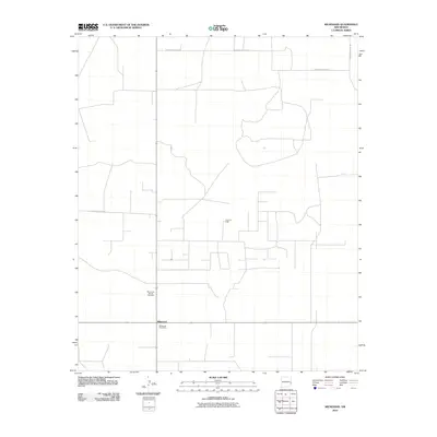
2010 Map of Milnesand
USGS Topo · Published 2010About this map
Milnesand serves as the primary focal point of this Eastern New Mexico landscape, situated at a junction where the high plains topography meets the region's energy infrastructure. The map reveals a remote ranching and energy-producing community, anchored by the Milnesand Post Office. This area is defined by its rectilinear road grid, including S Roosevelt Road 35 and S Roosevelt Road 39, which carve through the open terrain of Roosevelt County. The economic character of the region is evident through specialized landmarks such as the Todd Oil Field and the Milnesand Natural Gas Mast, indicating the importance of petroleum and natural gas extraction to the local economy during this period. The lack of dense residential development emphasizes the expansive, industrial-agricultural nature of the Llano Estacado.
Find a feature on this map
6 named features on this map. Tap any name to fly to it.
Don’t see what you’re looking for? This feature index may not catch every label — zoom into the map to look around manually.
Map Details
Editions of this 2010 Milnesand Map
This is the sole edition of this map. No revisions or reprints were ever made.
Other maps of this area

1954 · Brownfield
USGS Topo · 1:250,000

1958 · Brownfield
USGS Topo · 1:250,000

1962 · Brownfield
USGS Topo · 1:250,000

1972 · Milnesand SW
USGS Topo · 1:24,000

1972 · Bluit
USGS Topo · 1:24,000
1972 · Bledsoe SW
USGS Topo · 1:24,000

1972 · Garrison
USGS Topo · 1:24,000

1972 · Milnesand
USGS Topo · 1:24,000

1972 · Dora SW
USGS Topo · 1:24,000

1972 · Crossroads
USGS Topo · 1:24,000