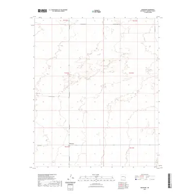
2023 Map of Milnesand
USGS Topo · Published 2023About this map
Milnesand serves as the focal point of this high-plains landscape, situated at the junction where Dora Main St meets the rural road network. The map illustrates a classic Llano Estacado grid system, where vast sections of land are delineated by straight-line roads like S Roosevelt Road 39 and S Roosevelt Road 35. This settlement pattern reflects the mid-century agricultural and ranching legacy of Roosevelt County, where human habitation is concentrated at key intersections while the surrounding terrain remains open and surveyed into large township and range blocks. Connectivity for this corner of New Mexico is maintained via State Hwy 258, which cuts through the southern portion of the quadrangle. The topography is subtle, characterized by the gentle undulations and depressions typical of the regional geography, providing a precise record of the local drainage and elevation patterns as they existed in the early 21st century.
Find a feature on this map
12 named features on this map. Tap any name to fly to it.
Don’t see what you’re looking for? This feature index may not catch every label — zoom into the map to look around manually.
Map Details
Editions of this 2023 Milnesand Map
This is the sole edition of this map. No revisions or reprints were ever made.
Other maps of this area

1954 · Brownfield
USGS Topo · 1:250,000

1958 · Brownfield
USGS Topo · 1:250,000

1962 · Brownfield
USGS Topo · 1:250,000

1972 · Milnesand SW
USGS Topo · 1:24,000

1972 · Bluit
USGS Topo · 1:24,000
1972 · Bledsoe SW
USGS Topo · 1:24,000

1972 · Garrison
USGS Topo · 1:24,000

1972 · Milnesand
USGS Topo · 1:24,000

1972 · Dora SW
USGS Topo · 1:24,000

1972 · Crossroads
USGS Topo · 1:24,000