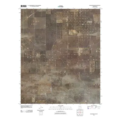
2010 Map of Milnesand SW
USGS Topo · Published 2010About this map
Milnesand Oil Field and the Vada Oil Field define the industrial landscape of this Lea County corner, where the extraction economy is mapped alongside an extensive grid of section-line roads. The territory is dominated by these petroleum developments, which are serviced by a network of local thoroughfares including S Roosevelt Road Y and S Roosevelt Rd W. Unlike more mountainous or water-rich regions, this 2010 survey reveals a highly organized, man-made geography of energy production and access. The southern portion of the quadrangle is bisected by County Rd-170, while smaller paths such as Vada Lee connect individual wells and ranch access points, showing the systematic infrastructure required for the region's oil and gas operations.
Find a feature on this map
6 named features on this map. Tap any name to fly to it.
Don’t see what you’re looking for? This feature index may not catch every label — zoom into the map to look around manually.
Map Details
Editions of this 2010 Milnesand SW Map
This is the sole edition of this map. No revisions or reprints were ever made.
Other maps of this area

1954 · Brownfield
USGS Topo · 1:250,000

1958 · Brownfield
USGS Topo · 1:250,000

1961 · Johnson Ranch
USGS Topo · 1:24,000

1962 · Brownfield
USGS Topo · 1:250,000

1970 · Johnson Ranch
USGS Topo · 1:24,000

1970 · Ranger Lake
USGS Topo · 1:24,000

1972 · Milnesand SW
USGS Topo · 1:24,000

1972 · Milnesand
USGS Topo · 1:24,000

1972 · Crossroads
USGS Topo · 1:24,000
1972 · Milnesand NW
USGS Topo · 1:24,000