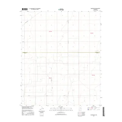
2017 Map of Milnesand SW
USGS Topo · Published 2017About this map
The border of Roosevelt Co Lea Co bisects this high plains landscape of southeastern New Mexico, defining a region where the vast, open terrain is organized by a geometric grid of rural roads and land divisions. This 2017 survey details the southern reaches of Roosevelt County and the northern boundary of Lea County, characterized by the Public Land Survey System townships of t8s r34e, t8s r35e, t9s r34e, and t9s r35e. The transport network relies on a series of local connectors, including S Roosevelt Rd W and S Roosevelt Road Y, which provide access to the intermittent ranching and agricultural tracts that define the local economy. Notable family-named routes such as Vada Lee and Crow Rd offer a more personal connection to the residents of this sparsely populated Llano Estacado region, while thoroughfares like La Mesa Rd and Co Rd 170 link the isolated townships together across the flat, semi-arid horizon.
Find a feature on this map
12 named features on this map. Tap any name to fly to it.
Don’t see what you’re looking for? This feature index may not catch every label — zoom into the map to look around manually.
Map Details
Editions of this 2017 Milnesand SW Map
This is the sole edition of this map. No revisions or reprints were ever made.
Other maps of this area

1954 · Brownfield
USGS Topo · 1:250,000

1958 · Brownfield
USGS Topo · 1:250,000

1961 · Johnson Ranch
USGS Topo · 1:24,000

1962 · Brownfield
USGS Topo · 1:250,000

1970 · Johnson Ranch
USGS Topo · 1:24,000

1970 · Ranger Lake
USGS Topo · 1:24,000

1972 · Milnesand SW
USGS Topo · 1:24,000

1972 · Milnesand
USGS Topo · 1:24,000

1972 · Crossroads
USGS Topo · 1:24,000
1972 · Milnesand NW
USGS Topo · 1:24,000