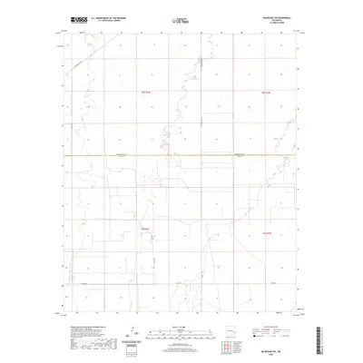
2020 Map of Milnesand SW
USGS Topo · Published 2020About this map
The Roosevelt Co Lea Co boundary line divides this High Plains landscape, where the survey lines of the Public Land Survey System dictate the movement of local traffic. Remote country routes like Vada Lee and Crow Rd follow these rigid section boundaries, providing access to a territory defined by large-scale ranching and land management. The terrain is remarkably subtle, featuring sparse contouring that highlights a series of shallow depressions and draws typical of the Llano Estacado. Local infrastructure is primarily represented by a network of rural county roads, including Co Rd 170 and S Roosevelt Rd W, which serve the expansive tracts of land between the sparsely populated townships of t8s r34e, t8s r35e, t9s r34e, and t9s r35e. This map illustrates the intersection of modern administration and the traditional grid-based settlement patterns of Eastern New Mexico.
Find a feature on this map
12 named features on this map. Tap any name to fly to it.
Don’t see what you’re looking for? This feature index may not catch every label — zoom into the map to look around manually.
Map Details
Editions of this 2020 Milnesand SW Map
This is the sole edition of this map. No revisions or reprints were ever made.
Other maps of this area

1954 · Brownfield
USGS Topo · 1:250,000

1958 · Brownfield
USGS Topo · 1:250,000

1961 · Johnson Ranch
USGS Topo · 1:24,000

1962 · Brownfield
USGS Topo · 1:250,000

1970 · Johnson Ranch
USGS Topo · 1:24,000

1970 · Ranger Lake
USGS Topo · 1:24,000

1972 · Milnesand SW
USGS Topo · 1:24,000

1972 · Milnesand
USGS Topo · 1:24,000

1972 · Crossroads
USGS Topo · 1:24,000
1972 · Milnesand NW
USGS Topo · 1:24,000