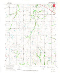
1966 Map of Minco NE
USGS Topo · Published 1967About this map
Cimarron Field and its associated heliport anchor this mid-1960s survey of the plains between Yukon and El Reno. The landscape is a transition of expanding municipal boundaries and agricultural roots, where the Oklahoma City corporate limits press westward into Canadian County. The section-line road network, including Richland Road and Cimarron Road, defines the settlement pattern, connecting rural outposts like the Banner Sch and several country churches.
Find a feature on this map
40 named features on this map. Tap any name to fly to it.
Don’t see what you’re looking for? This feature index may not catch every label — zoom into the map to look around manually.
Map Details
Editions of this 1966 Minco NE Map
3 editions found
Other maps of this area

1892 · Kingfisher
USGS Topo · 1:125,000

1893 · Oklahoma City
USGS Topo · 1:62,500

1893 · Minco
USGS Topo · 1:62,500

1895 · Kingfisher
USGS Topo · 1:125,000

1904 · Chickasha
USGS Topo · 1:125,000

1954 · Oklahoma City
USGS Topo · 1:250,000

1956 · Oklahoma City
USGS Topo · 1:62,500

1957 · Oklahoma City
USGS Topo · 1:250,000

1963 · Oklahoma City
USGS Topo · 1:250,000
1965 · Oklahoma City SW
USGS Topo · 1:24,000