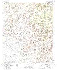
1963 Map of Mine Mountain
USGS Topo · Published 1985About this map
Tonto National Forest occupies this high desert landscape, dominated by the peaks of Mine Mountain and Pine Mountain. The mapping captures a network of resource extraction and seasonal water sources in the 1960s, evidenced by the central Mine and numerous isolated springs such as Mine Mountain Spring, Willow Spring, and Cold Water Spring. The terrain transitions from the distinct formations of The Rolls in the southwest to the jagged elevations of The Wata Ridges in the southeast. Evidence of human activity is sparse but specific, concentrated around Cline Cabin and a system of rugged transportation routes including a Jeep Trail and Pack Trail that follow natural contours through Brushy Basin and along the Natural Divide. Drainage patterns are clearly defined by Picadilla Creek and Mesquite Wash, which navigate the complex topography of the Picadilla region.
Find a feature on this map
29 named features on this map. Tap any name to fly to it.
Don’t see what you’re looking for? This feature index may not catch every label — zoom into the map to look around manually.
Map Details
Editions of this 1963 Mine Mountain Map
4 editions found
Other maps of this area

1904 · Ft. McDowell
USGS Topo · 1:62,500

1906 · Ft. McDowell
USGS Topo · 1:62,500

1907 · Roosevelt
USGS Topo · 1:125,000

1909 · Four Peaks
USGS Topo · 1:125,000

1912 · Roosevelt
USGS Topo · 1:125,000

1930 · Cave Creek
USGS Topo · 1:125,000

1939 · Cave Creek
USGS Topo · 1:125,000

1954 · Mesa
USGS Topo · 1:250,000

1957 · Mesa
USGS Topo · 1:250,000

1958 · Mesa
USGS Topo · 1:250,000