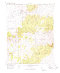
1958 Map of Minersville
USGS Topo · Published 1977About this map
Minersville sits at the eastern edge of the Escalante Desert, where the Beaver River emerges from the Mineral Mountains and Blue Mountains. This 1950s survey captures the region's complex water management system, centered on the Minersville Reservoir and Rocky Ford Dam. Agricultural infrastructure is evident in The Mile Ditch and a local School, while the presence of Uncle Benneys Orchard suggests small-scale cultivation amidst the arid landscape.
Find a feature on this map
68 named features on this map. Tap any name to fly to it.
Don’t see what you’re looking for? This feature index may not catch every label — zoom into the map to look around manually.
Map Details
Editions of this 1958 Minersville Map
3 editions found

Other maps of this area

1885 · St. George
USGS Topo · 1:250,000

1885 · Beaver
USGS Topo · 1:250,000

1886 · Kanab
USGS Topo · 1:250,000

1891 · St. George
USGS Topo · 1:250,000

1950 · Enoch
USGS Topo · 1:62,500

1950 · Enoch NE
USGS Topo · 1:24,000

1952 · Enoch NE
USGS Topo · 1:24,000

1953 · Ninemile Knoll
USGS Topo · 1:24,000

1953 · Milford Flat
USGS Topo · 1:24,000

1953 · Minersville
USGS Topo · 1:24,000