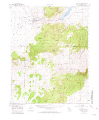
1958 Map of Minersville
USGS Topo · Published 1982About this map
Minersville serves as the focal point of this late 1950s survey, situated where the Beaver River flows toward the Escalante Desert. The landscape is a study in early water management and mineral extraction, featuring an intricate network of irrigation including the Low Line Canal, Minersville Canal, and The Mile Ditch. To the east, the Rocky Ford Dam contains the Minersville Reservoir, while the surrounding Mineral Mountains and Black Mountains reveal the area's mining history through the Goules Mine and Blue Ribbon Mine. Local genealogical interest is found at the town Cemetery and the uniquely named Uncle Benneys Orchard. The terrain is characterized by numerous springs and seeps, such as Plunge Spring and Jackrabbit Spring, which supported livestock and small-scale agriculture in this arid basin before modern development shifted the regional footprint.
Find a feature on this map
73 named features on this map. Tap any name to fly to it.
Don’t see what you’re looking for? This feature index may not catch every label — zoom into the map to look around manually.
Map Details
Editions of this 1958 Minersville Map
3 editions found

Other maps of this area

1885 · St. George
USGS Topo · 1:250,000

1885 · Beaver
USGS Topo · 1:250,000

1886 · Kanab
USGS Topo · 1:250,000

1891 · St. George
USGS Topo · 1:250,000

1950 · Enoch
USGS Topo · 1:62,500

1950 · Enoch NE
USGS Topo · 1:24,000

1952 · Enoch NE
USGS Topo · 1:24,000

1953 · Ninemile Knoll
USGS Topo · 1:24,000

1953 · Milford Flat
USGS Topo · 1:24,000

1953 · Minersville
USGS Topo · 1:24,000