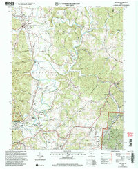
2002 Map of Minford
USGS Topo · Published 2006About this map
The Scioto River and Little Scioto River corridors define this landscape, where early 20th-century industry meets the rural hill country of southern Ohio. Industrial activity is evident at the Scioto Furnace site and numerous smaller nodes like Harrison Mills and Wheelers Mill. The map documents a dense network of family history markers, including Squire Cem, Old Bennett Cem, and the German Cem near Slocum. Transport and infrastructure are represented by the County Airport and the complex system of pipelines traversing the terrain. Pockets of the Wayne National Forest cover the eastern hills, while suburban additions like Happy Hours Addition and Rigrish Addition near Sciotodale signal mid-century residential growth along the river flats.
Find a feature on this map
101 named features on this map. Tap any name to fly to it.
Don’t see what you’re looking for? This feature index may not catch every label — zoom into the map to look around manually.
Map Details
Editions of this 2002 Minford Map
This is the sole edition of this map. No revisions or reprints were ever made.
Other maps of this area

1898 · Ironton
USGS Topo · 1:62,500

1900 · Ironton
USGS Topo · 1:62,500

1911 · Sciotoville
USGS Topo · 1:62,500

1912 · Oak Hill
USGS Topo · 1:62,500

1913 · Sciotoville
USGS Topo · 1:62,500

1926 · Greenup
USGS Topo · 1:48,000

1930 · Greenup
USGS Topo · 1:62,500
1953 · Portsmouth
USGS Topo · 1:24,000

1957 · Huntington
USGS Topo · 1:250,000

1960 · Huntington
USGS Topo · 1:250,000