
1951 Map of Minnekahta NE
USGS Topo · Published 1953About this map
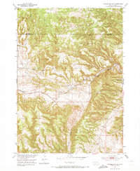
Harney National Forest dominates this 1951 landscape, where the rugged southern Black Hills are carved by deep drainages and canyons. The settlement at Erskine serves as a focal point along the Burlington and Chicago rail line, which follows the winding path of Hot Brook through Hot Brook Canyon. The map reveals the rural infrastructure of the early 1950s, showing local education hubs like Miller Sch and Cold Brook Sch situated near essential water sources like Cottonwood Springs Creek. Along the northern border, the transition from Custer Co to Fall River Co is clearly marked. This era represents a period before major modernization changed the local ranching and rail transport patterns, capturing a network of unimproved roads and small Cem sites tucked into the hills.
Find a feature on this map
15 named features on this map. Tap any name to fly to it.
Don’t see what you’re looking for? This feature index may not catch every label — zoom into the map to look around manually.
Map Details
Editions of this 1951 Minnekahta NE Map
2 editions found
Other maps of this area

1894 · Hermosa
USGS Topo · 1:125,000

1896 · Oelrichs
USGS Topo · 1:125,000

1896 · Harney Peak
USGS Topo · 1:125,000

1900 · Oelrichs
USGS Topo · 1:125,000

1901 · Hermosa
USGS Topo · 1:125,000

1901 · Harney Peak
USGS Topo · 1:125,000

1902 · Edgemont
USGS Topo · 1:125,000

1950 · Hot Springs
USGS Topo · 1:24,000

1950 · Cascade Springs
USGS Topo · 1:24,000

1950 · Angostura Reservoir
USGS Topo · 1:24,000