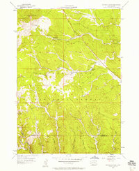
1956 Map of Minnesota Ridge
USGS Topo · Published 1958About this map
Rochford sits at the southern edge of this mid-century survey, a period when the industrial footprint of the Black Hills was shifting from active extraction to forest management. The presence of the Montana Mine (Inactive) and the Boxelder Sch (Abandoned) reflects a landscape in transition, where earlier mining and ranching infrastructure was beginning to fade. The high ground is dominated by the Custer Lookout Tower atop Custer Peak, providing a vital fire-watch vantage over the Black Hills National Forest and the namesake Minnesota Ridge.
Find a feature on this map
25 named features on this map. Tap any name to fly to it.
Don’t see what you’re looking for? This feature index may not catch every label — zoom into the map to look around manually.
Map Details
Editions of this 1956 Minnesota Ridge Map
Other maps of this area

1894 · Deadwood
USGS Topo · 1:125,000

1899 · Sturgis
USGS Topo · 1:62,500

1900 · Spearfish
USGS Topo · 1:62,500

1901 · Deadwood
USGS Topo · 1:125,000

1915 · Spearfish
USGS Topo · 1:62,500

1915 · Sturgis
USGS Topo · 1:62,500

1916 · Deadwood
USGS Topo · 1:125,000

1953 · Nemo
USGS Topo · 1:24,000

1953 · Rapid City
USGS Topo · 1:250,000

1954 · Silver City
USGS Topo · 1:24,000