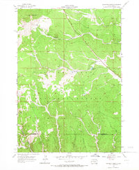
1956 Map of Minnesota Ridge
USGS Topo · Published 1966About this map
Minnesota Ridge dominates the central topography of this mid-century survey, a high-relief landscape within the Black Hills National Forest along the Lawrence and Pennington county line. The settlement of Rochford anchors the southwestern corner at the junction of the South Fork Rapid Creek and the North Fork Rapid Creek, where two major rail lines, the Chicago and North Western and the Burlington and Quincy, converge. This junction reflects a legacy of industrial transport through the hills, supporting local extractive efforts like the Montana Mine (Inactive) further north.
Find a feature on this map
26 named features on this map. Tap any name to fly to it.
Don’t see what you’re looking for? This feature index may not catch every label — zoom into the map to look around manually.
Map Details
Editions of this 1956 Minnesota Ridge Map
Other maps of this area

1894 · Deadwood
USGS Topo · 1:125,000

1899 · Sturgis
USGS Topo · 1:62,500

1900 · Spearfish
USGS Topo · 1:62,500

1901 · Deadwood
USGS Topo · 1:125,000

1915 · Spearfish
USGS Topo · 1:62,500

1915 · Sturgis
USGS Topo · 1:62,500

1916 · Deadwood
USGS Topo · 1:125,000

1953 · Nemo
USGS Topo · 1:24,000

1953 · Rapid City
USGS Topo · 1:250,000

1954 · Silver City
USGS Topo · 1:24,000