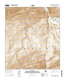
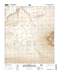
2016 Map of Misheguk Mountain D-4 SW
USGS Topo · Published 2016About this map
Utukok River dominates the northeastern corner of this remote landscape in the North Slope Borough, where it is joined by the winding course of Adventure Creek. This 2016 survey illustrates a vast, uninhabited Arctic drainage system defined by high-elevation contours and seasonal watercourses. The drainage of Adventure Creek flows northward through several townships, including t7s r39w and t8s r39w, showing the complex hydrological network that feeds the larger river systems of the region. To the west, the headwaters of Plunge Creek emerge from the high ridges of t6s r40w, carving narrow valleys through the upland terrain. This map serves as a primary record of the topographic character and watershed boundaries in a region where the land remains largely untouched by permanent settlement or infrastructure.
Find a feature on this map
10 named features on this map. Tap any name to fly to it.
Don’t see what you’re looking for? This feature index may not catch every label — zoom into the map to look around manually.
Map Details
Editions of this 2016 Misheguk Mountain D-4 SW Map
This is the sole edition of this map. No revisions or reprints were ever made.
Other maps of this area

1951 · Misheguk Mountain
USGS Topo · 1:250,000

1956 · Misheguk Mountain
USGS Topo · 1:250,000
1984 · Misheguk Mountain C-5
USGS Topo · 1:63,360
1984 · Misheguk Mountain D-5
USGS Topo · 1:63,360
1984 · Misheguk Mountain C-4
USGS Topo · 1:63,360
1984 · Misheguk Mountain D-4
USGS Topo · 1:63,360
2015 · Misheguk Mountain C-5 NE
USGS Topo · 1:25,000
2015 · Misheguk Mountain D-5 SE
USGS Topo · 1:25,000
2016 · Misheguk Mountain C-4 NW
USGS Topo · 1:25,000
2016 · Misheguk Mountain D-4 NE
USGS Topo · 1:25,000