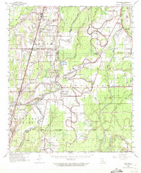
1959 Map of Mitchiner
USGS Topo · Published 1972About this map
Poverty Pt. stands as a significant archaeological landmark in this delta landscape, surrounded by numerous Indian Mounds and earthworks along the meandering Bayou Macon. The settlement patterns here follow the high ground between the bayou and the Tensas Bayou to the east, revealing a rural economy transitioning from traditional river landings like Floyd Ldg and Jackson Ldg to the industrial presence of the Epps Gas Field. The map meticulously records the social centers of the late 1950s, documenting dozens of country congregations such as Evening Star Ch, Magnolia Ch & Sch, and Herringville Ch. Navigation and transport are central themes, from the active Missouri Pacific railroad line through Pioneer and Darnell to the noted Head of Navigation on the bayou, illustrating how these waterways continued to dictate the geography of East Carroll Parish and West Carroll Parish.
Find a feature on this map
79 named features on this map. Tap any name to fly to it.
Don’t see what you’re looking for? This feature index may not catch every label — zoom into the map to look around manually.
Map Details
Editions of this 1959 Mitchiner Map
2 editions found

Other maps of this area

1909 · Baxter Bayou
USGS Topo · 1:24,000

1909 · Lake Providence
USGS Topo · 1:24,000

1909 · Tallulah
USGS Topo · 1:24,000

1911 · Lake Providence
USGS Topo · 1:31,680

1911 · Baxter Bayou
USGS Topo · 1:24,000

1914 · Baxter Bayou
USGS Topo · 1:31,680

1935 · Baskinton
USGS Topo · 1:62,500

1935 · Hurricane
USGS Topo · 1:62,500

1935 · Waverly
USGS Topo · 1:62,500

1935 · Oak Grove
USGS Topo · 1:62,500