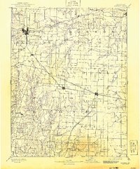
1890 Map of Moberly
USGS Topo · Published 1926About this map
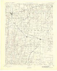
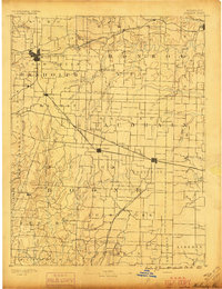
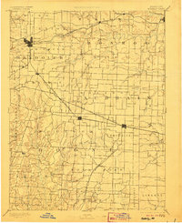
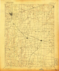
Moberly and its surrounding rail junctions dominate this late 19th-century landscape, where several major transit lines intersect at the height of the steam era. Surveyed by H.L. Baldwin Jr. in 1887, the map illustrates how the Wabash Railroad, Chicago and Alton Railroad, and Missouri Pacific Railroad dictated the growth of settlements like Sturgeon, Centralia, and Renick. While the northern sections are defined by these steel arteries, the southern portion reveals a complex drainage network feeding into the Perche Creek and the Middle Fork Salt River. Local landmarks and small rural communities such as Dripping Spring, Middle Grove, and Hallsville are clearly situated within the larger boundaries of Randolph, Monroe, and Boone counties. The interplay of topography and transport is evident, with roads and tracks following the natural ridges above deep-cut branches like Grindstone Branch and Silver Creek.
Find a feature on this map
78 named features on this map. Tap any name to fly to it.
Don’t see what you’re looking for? This feature index may not catch every label — zoom into the map to look around manually.
Map Details
Editions of this 1890 Moberly Map
6 editions found
Other maps of this area

1886 · Jefferson City
USGS Topo · 1:125,000

1888 · Boonville
USGS Topo · 1:125,000

1890 · Mexico
USGS Topo · 1:125,000

1890 · Moberly
USGS Topo · 1:125,000

1890 · Glasgow
USGS Topo · 1:125,000

1890 · Fulton
USGS Topo · 1:125,000

1894 · Jefferson City
USGS Topo · 1:125,000

1903 · Palmyra
USGS Topo · 1:125,000
1908 · Macon
USGS Topo · 1:62,500
1910 · Macon
USGS Topo · 1:62,500