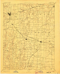
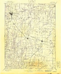
1890 Map of Moberly
USGS Topo · Published 1906About this map
The rail junction at Moberly serves as a primary hub for Central Missouri in this late 19th-century landscape, where the Wabash Railroad and the Missouri Pacific Railroad converge. This era was defined by the rapid growth of agricultural and shipping centers, as evidenced by the dense network of tracks connecting Sturgeon, Centralia, and the county seat at Paris. The terrain is deeply carved by the Middle Fork Salt River and the South Fork, creating a drainage pattern that dictated the placement of early roads and small rural communities like Middle Grove and Dripping Spring.
Find a feature on this map
87 named features on this map. Tap any name to fly to it.
Don’t see what you’re looking for? This feature index may not catch every label — zoom into the map to look around manually.
Map Details
Editions of this 1890 Moberly Map
6 editions found
Other maps of this area

1886 · Jefferson City
USGS Topo · 1:125,000

1888 · Boonville
USGS Topo · 1:125,000

1890 · Mexico
USGS Topo · 1:125,000

1890 · Moberly
USGS Topo · 1:125,000

1890 · Glasgow
USGS Topo · 1:125,000

1890 · Fulton
USGS Topo · 1:125,000

1894 · Jefferson City
USGS Topo · 1:125,000

1903 · Palmyra
USGS Topo · 1:125,000

1908 · Macon
USGS Topo · 1:62,500

1910 · Macon
USGS Topo · 1:62,500