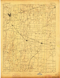
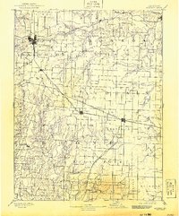
1890 Map of Moberly
USGS Topo · Published 1896About this map
Moberly serves as the dominant rail hub in this late nineteenth-century landscape, where the Wabash Railroad and Missouri Pacific Railroad converge. The terrain is defined by the branching drainage of the Middle Fork Salt River and the South Fork of Salt River, which carve through the townships of Marion, Monroe, and Audrain. Smaller rural settlements like Middle Grove, Dripping Spring, and Galbreaths are scattered throughout the agricultural tracts, often positioned near the numerous creek branches such as Coy Branch and Silver Fork Creek. The Chicago and Alton Railroad cuts a diagonal path across the center, linking the communities of Sturgeon and Centralia. This survey captures a moment when North-Central Missouri was a highly interconnected network of rail-reliant towns and water-dependent farms, just before the expansion of modern road systems.
Find a feature on this map
83 named features on this map. Tap any name to fly to it.
Don’t see what you’re looking for? This feature index may not catch every label — zoom into the map to look around manually.
Map Details
Editions of this 1890 Moberly Map
6 editions found
Other maps of this area

1886 · Jefferson City
USGS Topo · 1:125,000

1888 · Boonville
USGS Topo · 1:125,000

1890 · Mexico
USGS Topo · 1:125,000

1890 · Moberly
USGS Topo · 1:125,000

1890 · Glasgow
USGS Topo · 1:125,000

1890 · Fulton
USGS Topo · 1:125,000

1894 · Jefferson City
USGS Topo · 1:125,000

1903 · Palmyra
USGS Topo · 1:125,000

1908 · Macon
USGS Topo · 1:62,500

1910 · Macon
USGS Topo · 1:62,500