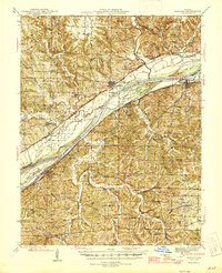
1945 Map of Mokane
USGS Topo · Published 1945About this map
St Aubert and Cote Sans Dessein define the landscape where the Missouri River cuts through the borderlands of Callaway, Osage, and Cole counties. The rail corridor of the Missouri Pacific railroad tracks the northern bank, serving river towns like Mokane and Tebbetts. This 1945 edition reveals a rural interior densely packed with neighborhood institutions, including the Oak Grove Sch and Zion Hope Ch, reflecting a time when local schools and churches were the primary anchors of Missouri river valley life.
Find a feature on this map
68 named features on this map. Tap any name to fly to it.
Don’t see what you’re looking for? This feature index may not catch every label — zoom into the map to look around manually.
Map Details
Editions of this 1945 Mokane Map
3 editions found

Other maps of this area

1886 · Jefferson City
USGS Topo · 1:125,000

1888 · Tuscumbia
USGS Topo · 1:125,000

1890 · Fulton
USGS Topo · 1:125,000

1894 · Tuscumbia
USGS Topo · 1:125,000

1894 · Jefferson City
USGS Topo · 1:125,000

1928 · Fulton
USGS Topo · 1:62,500

1931 · Fulton
USGS Topo · 1:62,500

1934 · Linn
USGS Topo · 1:48,000

1934 · Bland
USGS Topo · 1:62,500

1935 · Morrison
USGS Topo · 1:48,000