
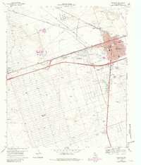
1969 Map of Monahans
USGS Topo · Published 1971About this map
Monahans serves as the focal point of this West Texas landscape, showing a town organized around the Texas and Pacific railroad and a grid of residential streets including Tenth St and Fifteenth St. The era's municipal growth is evident in the cluster of civic landmarks such as the County Memorial Hospital, County Library, and several neighborhood schools like Edwards Sch and Browne Sch. Beyond the city limits, the map illustrates the infrastructure of the Permian Basin's petroleum economy, with an extensive Oil Field network of pipelines and named water sources like Bitter Well and Honky Tonk Well. To the west, the smaller communities of Wickett and Thorntonville appear alongside the industrial footprint of the Powerplant and various Gravel Pits, while the Wagonwheel Ranch represents the traditional ranching heritage of Ward Co.
Find a feature on this map
56 named features on this map. Tap any name to fly to it.
Don’t see what you’re looking for? This feature index may not catch every label — zoom into the map to look around manually.
Map Details
Editions of this 1969 Monahans Map
2 editions found
Other maps of this area

1931 · Barstow
USGS Topo · 1:125,000

1954 · Pecos
USGS Topo · 1:250,000

1957 · Pecos
USGS Topo · 1:250,000

1963 · China Lake NE
USGS Topo · 1:24,000

1968 · Monahans SE
USGS Topo · 1:24,000

1968 · Cowden Place
USGS Topo · 1:24,000

1968 · China Ranch
USGS Topo · 1:24,000

1969 · Ozark Lake
USGS Topo · 1:24,000

1969 · Pyote NE
USGS Topo · 1:24,000

1969 · Pyote East
USGS Topo · 1:24,000