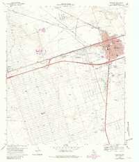
1969 Map of Monahans
USGS Topo · Published 1981About this map
The North Oil Field and the Missouri Pacific railroad define the landscape of this Ward County region during the late 1960s. The bustling town of Monahans serves as the central hub, showing a developed street grid including Main Ave and Stockton Ave, along with essential community infrastructure like the County Memorial Hospital and the Municipal Cem. Education is well-represented by several facilities, including High Sch and Taturn Sch.
Find a feature on this map
43 named features on this map. Tap any name to fly to it.
Don’t see what you’re looking for? This feature index may not catch every label — zoom into the map to look around manually.
Map Details
Editions of this 1969 Monahans Map
2 editions found

Other maps of this area

1931 · Barstow
USGS Topo · 1:125,000

1954 · Pecos
USGS Topo · 1:250,000

1957 · Pecos
USGS Topo · 1:250,000

1963 · China Lake NE
USGS Topo · 1:24,000

1968 · Monahans SE
USGS Topo · 1:24,000

1968 · Cowden Place
USGS Topo · 1:24,000

1968 · China Ranch
USGS Topo · 1:24,000

1969 · Ozark Lake
USGS Topo · 1:24,000

1969 · Pyote NE
USGS Topo · 1:24,000

1969 · Pyote East
USGS Topo · 1:24,000