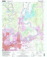
1999 Map of Monroe North
USGS Topo · Published 2001About this map
The winding loops of the Ouachita River and the extensive Black Bayou Lake dominate this northern survey of the regional hub. The landscape is a complex hybrid of urban development and alluvial wetlands, where the Chauvin Swamp and the Monroe Gas Field border the growing city streets. Within Monroe, the map documents a concentration of institutional history, including NE Louisiana State College and several educational landmarks such as Union High Sch and Booker T Washington Sch. Genealogists will find the city's diverse mortuary history well-represented through the Jewish Cem, St Matthew Cem, and the Old City Cem. The presence of the Bayou de Siard Country Club and the Fish Hatchery illustrate the mid-century recreational and conservation priorities established along the banks of Bayou de Siard.
Find a feature on this map
80 named features on this map. Tap any name to fly to it.
Don’t see what you’re looking for? This feature index may not catch every label — zoom into the map to look around manually.
Map Details
Editions of this 1999 Monroe North Map
This is the sole edition of this map. No revisions or reprints were ever made.
Other maps of this area

1935 · Collinston
USGS Topo · 1:62,500

1935 · Alto
USGS Topo · 1:62,500

1935 · Drew
USGS Topo · 1:62,500

1940 · Monroe
USGS Topo · 1:62,500

1955 · Jackson
USGS Topo · 1:250,000

1955 · Shreveport
USGS Topo · 1:250,000

1956 · Shreveport
USGS Topo · 1:250,000

1957 · Monroe North
USGS Topo · 1:62,500

1957 · West Monroe North
USGS Topo · 1:24,000

1957 · Mangham
USGS Topo · 1:62,500