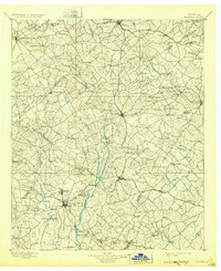
1896 Map of Monroe
USGS Topo · Published 1932About this map
Alcovy River and the Yellow River serve as the primary drainage for this agricultural and early industrial landscape, where the survey work of H.B. Blair and J.W. Thom reveals a region transitioning toward a railroad-centered economy. The path of the Georgia R. R. connects established centers like Covington and Social Circle, while the Seaboard Air Line cuts through the northern reaches near Lawrenceville. Local commerce is anchored by sites such as the Paper Mills and various shoals, including Bramblett Shoals and Indian Shoals, which provided the water power necessary for mill operations before the widespread adoption of steam and electricity.
Find a feature on this map
127 named features on this map. Tap any name to fly to it.
Don’t see what you’re looking for? This feature index may not catch every label — zoom into the map to look around manually.
Map Details
Editions of this 1896 Monroe Map
5 editions found
Other maps of this area

1888 · Atlanta
USGS Topo · 1:125,000

1890 · Suwanee
USGS Topo · 1:125,000

1890 · Atlanta
USGS Topo · 1:125,000

1891 · Gainesville
USGS Topo · 1:125,000

1891 · Carnesville
USGS Topo · 1:125,000

1892 · Atlanta
USGS Topo · 1:125,000

1894 · Suwanee
USGS Topo · 1:125,000

1895 · Atlanta
USGS Topo · 1:125,000

1896 · Monroe
USGS Topo · 1:125,000

1953 · Atlanta
USGS Topo · 1:250,000