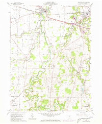
1960 Map of Monroeville
USGS Topo · Published 1973About this map
Monroeville and the surrounding Firelands of Huron County are defined here by a dense network of early mid-century transportation and small agricultural hamlets. The landscape is carved by the winding forks of the Huron River, including the East Branch and West Branch, which dictate the placement of early settlements like Standardsburg and Peru. The map reveals a robust rail economy with lines from the Norfolk and Western, Penn Central, and Baltimore and Ohio railroads converging near the regional hubs of Norwalk and Monroeville.
Find a feature on this map
58 named features on this map. Tap any name to fly to it.
Don’t see what you’re looking for? This feature index may not catch every label — zoom into the map to look around manually.
Map Details
Editions of this 1960 Monroeville Map
2 editions found
Other maps of this area

1901 · Bellevue
USGS Topo · 1:62,500

1903 · Bellevue
USGS Topo · 1:62,500

1904 · Sandusky
USGS Topo · 1:62,500

1915 · Norwalk
USGS Topo · 1:62,500

1915 · Siam
USGS Topo · 1:62,500

1944 · Norwalk
USGS Topo · 1:62,500

1956 · Toledo
USGS Topo · 1:250,000

1959 · Kimball
USGS Topo · 1:24,000

1959 · Milan
USGS Topo · 1:24,000
1959 · Bellevue
USGS Topo · 1:24,000